Imagine that your dad or mom built something huge and important — for example, the road that everyone in town uses. And then you yourself start using that road every day. That is how the children of the workers who built Seattle’s streetcar system in the early 1900s felt. But these kids did more than just take pride in their parents — they did something remarkable that helped thousands of people and has survived to this day.
Builders from faraway lands and their children-translators
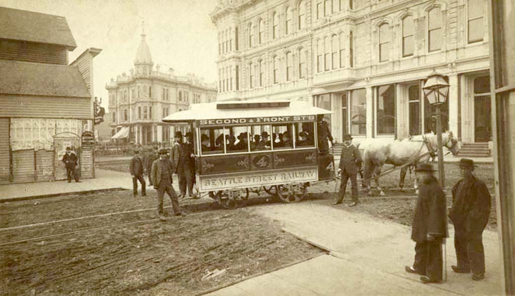
In the 1900–1910s thousands of people came to Seattle from Italy, Japan, Norway and other countries. Many of them found work building the streetcar system — laying tracks, building stations, crafting wooden seats inside the cars. Italian stonemasons set cobblestones around the tracks, Japanese carpenters carved patterns on the wooden panels inside the streetcars, Norwegian engineers checked that the wires were properly taut.
Their children attended American schools and learned English quickly. But at home they spoke their parents’ languages — Italian, Japanese, Norwegian. These kids became bridges between two worlds: they understood both the newcomers to America and those born here.
When the streetcar system began operating, something unexpected happened. New immigrants who didn’t speak English were afraid to use the streetcars. They didn’t understand which route went where, where to get off, or how much to pay. Street names at stops were written only in English. So the workers’ children came up with a way to help.
Maps drawn by children’s hands
Schoolchildren began drawing maps of the streetcar routes — but not ordinary ones; these were special. On these maps the stop names were written in two or even three languages. For example, a girl named Kiku Yamada, whose father made the wooden benches for the streetcars, drew a map of the line that ran from the port (where many Japanese immigrants worked) to the fish market. She labeled each stop in English and with Japanese characters. Next to some stops she drew small pictures — a fish by the market, a ship by the port, a church by the church.
A boy named Giovanni Rossi, the son of an Italian stonemason, made his map even more detailed. He not only labeled stops in Italian and English but also wrote how much the fare cost (five cents for adults, free for children under six) and what time the first and last streetcars ran. He even drew arrows showing where to transfer from one line to another.
These maps were drawn at home, on kitchen tables, using ordinary paper, pencils and ink. Sometimes the children colored different routes in different colors — red, blue, green. Then they brought their maps to shops, churches and community centers in neighborhoods where immigrants lived. Shopkeepers would hang the maps on walls or place them on counters so people could look before they traveled.
How the maps became family treasures
Very soon these children's maps became incredibly popular. Families copied them by hand and passed them around. When a new immigrant came to Seattle, relatives or acquaintances would give them one of these maps — it was one of the first gifts that helped a person feel less lost in a large unfamiliar city.
Some families kept these maps for years, even after they learned English and memorized all the routes. The maps reminded them of the difficult but important time when they were just starting life in America. In the margins people sometimes wrote notes: “Aunt Maria works here,” “there’s a good doctor who speaks Italian,” “this shop sells rice from Japan.”
The child-cartographers were proud of their work too. They saw adults thanking them, saw strangers stop being afraid of the streetcars and start riding freely around town. Some of the kids continued updating their maps when new routes opened or schedules changed. It was their way of helping the parents who had built the streetcars — the children made sure those streetcars served everyone, regardless of what language they spoke.
The end of the streetcars and the maps’ second life
In the 1940s Seattle’s streetcar system began to disappear. The city decided buses and automobiles were the future and streetcars were the past. Tracks were ripped out of the ground, cars were sold off or sent to the scrap heap. Many of the workers who had built the system had by then grown old. Their children were grown too; some moved to other cities, others opened shops and workshops in Seattle.
But the maps they had once drawn did not disappear. Families continued to store them in boxes with photographs and letters, as mementos of an important period in their history. In the 1990s, when the Museum of History and Industry (MOHAI) in Seattle began collecting documents about the immigrants who built the city, historians were amazed to discover these children’s maps.
Today several of those maps are kept in the museum. One of them — Kiku Yamada’s map — hangs in a special frame in the transportation exhibit. Next to it is a plaque that reads: “This map was drawn by an 11-year-old girl to help people who did not speak English use the streetcars built by her father and his friends.”
Why this story matters
The story of the children’s streetcar maps teaches us several important things. First, even children can solve real, serious problems. Schoolchildren didn’t just wait for adults to figure out how to help immigrants navigate the city — they picked up pencils and paper and did what was needed.
Second, when people build something together — whether roads, houses or whole cities — they create not only structures and tracks but also connections between people. Seattle’s streetcar system disappeared almost eighty years ago, but the story of how immigrants and their children helped one another lives on.
And third, sometimes the simplest things — a hand-drawn map labeled in two languages — can change someone’s life. For a person who has just arrived in an unfamiliar country and doesn’t understand the language, such a map was more than a sheet of paper. It was a message: “We are glad you are here. We will help you find your way.”
Today, when you ride a bus or subway and see signs in multiple languages, remember the children of Seattle who more than a century ago first understood: the city belongs to everyone, and everyone should be able to find their place in it.